A receiver you bought is a box somebody else built. A number you read on a screen is a number somebody else computed. These five objects are neither. You print them, or you cut them out of a cereal box, and then you go outside and measure the world with them. The dimensions come out of the same geometry the rest of this site argues from. If that geometry were wrong, these things would not work.
A horizontal sundial has a blade, called the gnomon, standing on a plate. The blade’s sloping edge has to point at the celestial pole. On a globe, that has a consequence you can measure with a protractor: the angle between the blade and the plate equals your latitude. Nothing else. Not the season, not the time, not the maker’s taste. Your latitude.
And the hour lines are not evenly spaced. They obey one equation:
| Latitude | 1 h | 2 h | 3 h | 4 h | 5 h | 6 h |
|---|---|---|---|---|---|---|
| 25°N | 6.5° | 13.7° | 22.9° | 36.2° | 57.6° | 90.0° |
| 35°N | 8.7° | 18.3° | 29.8° | 44.8° | 65.0° | 90.0° |
| 45°N | 10.7° | 22.2° | 35.3° | 50.8° | 69.2° | 90.0° |
| 55°N | 12.4° | 25.3° | 39.3° | 54.8° | 71.9° | 90.0° |
Those numbers are why the file is cut per latitude. A dial for 45°N is plainly wrong at 25°N, and it is wrong by enough to see on a summer afternoon. Take the file nearest your latitude.
Take the file nearest your latitude, in 5° steps. Set it flat, point the blade at true north (not magnetic), and read the shadow.
| What | File | Note |
|---|---|---|
| 25°N | sundial-25N.stl | Blade rises 25° from the plate. 142 × 141 × 33 mm. |
| 30°N | sundial-30N.stl | Blade rises 30° from the plate. 142 × 141 × 40 mm. |
| 35°N | sundial-35N.stl | Blade rises 35° from the plate. 142 × 141 × 48 mm. |
| 40°N | sundial-40N.stl | Blade rises 40° from the plate. 142 × 141 × 57 mm. |
| 45°N | sundial-45N.stl | Blade rises 45° from the plate. 142 × 141 × 66 mm. |
| 50°N | sundial-50N.stl | Blade rises 50° from the plate. 142 × 141 × 78 mm. |
| 55°N | sundial-55N.stl | Blade rises 55° from the plate. 142 × 141 × 93 mm. |
| 60°N | sundial-60N.stl | Blade rises 60° from the plate. 142 × 141 × 112 mm. |
Or get one cut for your latitude, not the nearest five degrees. The sundial generator in entry 75 now has a download button. Slide it to your latitude, press the button, and it builds the file in your browser. Nothing is uploaded anywhere, and a reader at 43.7°N gets 43.7°.
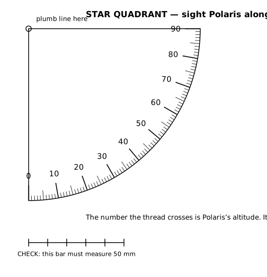
Sight Polaris along the top edge. Let the thread hang. Read where it crosses the scale. That number is your latitude, and you did not consult anybody to get it.
This is the instrument that ran the age of sail, and it is a quarter of a circle with a weight on a string. It also runs the argument in entry 70 to its conclusion, because the flat model has to explain the same reading with a lamp hanging over the disc, and it cannot do it twice with the same lamp. Polaris at 60° demands a lamp 5,778 km up. At 45° it demands 5,004 km. At 30° it demands 3,852 km.
Thread through the corner hole, a nut or a coin for the weight, and two pinholes for the sight line.
| What | File | Note |
|---|---|---|
| 3D print | star-quadrant.stl | 90 × 90 × 16 mm. 1° graduations on a 90 mm arc. |
| Paper, no printer needed | template-star-quadrant.svg | True scale. Glue to card. Print at 100 percent and check the 50 mm bar. |
This is the important one, and it is the plainest object here: a flat plate with a pin standing on it.
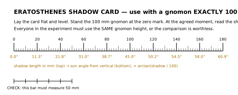
The pin is 100.0 millimeters tall, to the tip, and not a hair more. That is the entire design. It means the shadow length in millimeters gives the Sun’s angle with no calibration and no arithmetic anybody can dispute: the angle is arctan(shadow ÷ 100). Because everyone in the experiment prints the same file, nobody can blame a disagreement on whose stick was whose.
How to run it. Print three. Post two of them to friends who live well north and south of you. Agree on one moment, to the minute, and all three of you measure the shadow. Then compare.
| What | File | Note |
|---|---|---|
| 3D print | eratosthenes-gnomon.stl | Pin 100.0 mm to the tip. 150 × 90 mm base, with a recess for a bubble level. |
| Paper, no printer needed | template-eratosthenes.svg | A shadow scale in mm, with the angle printed under it. Use it with any 100 mm gnomon. |
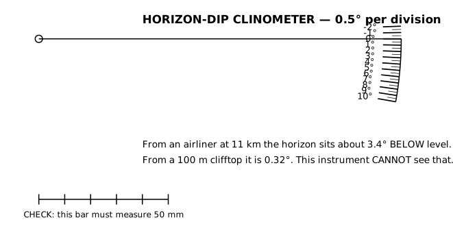
On a flat Earth the horizon rises to meet your eye, and it sits at eye level however high you climb. On a globe it drops below level, by an angle that grows with your altitude. Measure the drop and the model is on the line.
Sight the horizon along the top edge, let the plumb hang, read the arc. Divisions are 0.5°, spread over a 140 mm radius so that half a degree is a millimeter and a half of arc and you can see it.
| What | File | Note |
|---|---|---|
| 3D print | horizon-clinometer.stl | 138 × 31 × 16 mm. 0.5° per division on a 140 mm arc. |
| Paper, no printer needed | template-clinometer.svg | True scale. Card, a pin and a thread. |
The smallest object here and the one that opens the most doors. It holds two rods at 120°, which is the angle the weather-satellite V-dipole wants, and it holds them there when the wind gets up, which a terminal block does not.
Cut the rods to 53.4 cm each, for the 137 MHz band. That length is not a convention. It comes out of the speed of light divided by the frequency, and the whole derivation is on the antenna page. Feed it with 50 ohm coax: center conductor to one rod, braid to the other.
| What | File | Note |
|---|---|---|
| 3D print | vdipole-120-holder.stl | 46 × 34 × 16 mm. Prints in under an hour. |
| Feature | Size | Note |
|---|---|---|
| Rod bores | 4.2 mm | A clearance fit on 4 mm rod. Brazing rod, welding rod or brass tube. Check what you own before you print. |
| Angle between them | 120.0° | Held by the block, not by your patience. |
| Coax hole | 6.4 mm | Straight up the middle, so the feedline leaves at right angles to the elements. |
| Mast slots | 4 × 4 mm | Both sides, for cable ties. Any broom handle will do. |
Then go and pull a photograph of the Earth out of the sky with it. That is Level 1, and it costs about $30.
None of these objects proves the shape of the Earth by existing. A lump of plastic proves nothing at all, and we are not going to pretend otherwise.
What they do is close the last door. The standing objection to every measurement on this site is that somebody else made the instrument, somebody else wrote the software, somebody else supplied the number. Now the instrument is yours. You cut it from a file whose dimensions came out of the geometry, and when you take it outside, it gives you the number the geometry predicted before you started.
You have taken one more thing out of the hands of people you do not trust, and the answer did not change.